Keynsham & Saltford
Local History Society


Maps, Useful Links & FAQs
On this page you will find access to an old map of Keynsham, which was put on display at our 'Pop-Up Museum' in 2023. This map was of particular interest to visitors who have lived in Keynsham and helped them to see what the towns were like in the 1880s. This map can be zoomed in or out to see additional detail.
We have also added some useful websites and links that visitors may find of use.

Visitors may also find the below link to the website 'Bath and North East Somerset - Know Your Place' of interest. This site provides access to maps and locations of historical interest for the Bristol area. Others are available.
Useful Links & Services
Below we have provided links and details of websites and organisations that may be of use to anyone interested in local history. Click on the image and it will take you to the website.

Keynsham Abbey Working Group

Saltford Brass Mill

Bitton Parish History Group

Avon Local History & Archaeology

Saltford Environment Group

Bristol Industrial Archaeological Society

Bristol Civic Society

South Glos Mines Research Grou[

Albert Mill Heritage Site

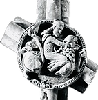
The Samson Boss
What is it?
The image you can see to the left is a photograph of a large 'ceiling boss' discovered during the archaeological digs that took place on the site of Keynsham Abbey between the 1960s-1990s. This 'boss' has been called 'Samson and the Lion' but there is some debate as to whether it is Samson or of 'David and the Lion'. This boss was sent to Rome for examination and returned to the BANES archives. At some point, it would be lovely to have this stunning item of medieval stonemasonry on permanent display within Keynsham.
The Great Flood of 1968
What caused it?
The Great Flood of 10th July 1968
The storm that passed across southern England on 10th July was at its most severe over the upper Chew valley where rainfall totals exceeded 6 inches. The valley is steep-sided and when vegetation and soil could absorb no more the water poured into the ditches and tributaries of the river causing the water level to rise very rapidly. Large flows move more quickly and the destructive power of the water washed away bridges and some buildings in its path. As it neared Keynsham the flood water hit the wall across the valley at Chewton Keynsham. When that collapsed the resulting “wall” of water moved downstream. Above Albert Mill the valley narrows so the flood deepened and then hit the Dapps Hill Bridge area of Keynsham like a tidal wave, flooding houses to the top of the ground floor. At Bath Hill Bridge a stranded car was washed off the bridge and three of the occupants died. Nearby shops and houses were badly damaged.
The next morning saw a huge recovery operation begin, but it took several years to replace the bridges and buildings destroyed, whilst many of those affected saw their lives changed forever.
Credit: Richard Dyson, 2026. Photo by Tony Wadley
_jpg.jpeg)

Common abbreviations in history
Abbreviations used by historians and on this website
Within historical writing (including this website), abbreviations are a common feature. To assist, we have listed some of the more common abbreviations:
-
CE - Common era. It is a secular term used for the same years as AD (Anno Domino).
-
ASC - Anglo-Saxon Chronicle. A set of annals listing dates and events in history.
-
K&S LHS - Keynsham and Saltford Local History Society.